

[ad_1]
New satellite imagery has revealed that the devastating floods in Nepal were triggered not only by a glacier collapse but also by a massive failure of the bedrock beneath it, according to a report by The Week.
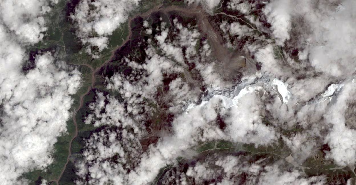
Geomorphologists Kristen Cook and Dan Shugar said further analysis of satellite images showed that a large section of the mountainside had collapsed along with part of the glacier.
“There was a big bedrock failure that took part of the glacier with it,” Shugar, an associate professor at the University of Calgary, said. The glacier broke off in a north-west direction before falling westward into the river channel.
Initial satellite images taken on Wednesday were obscured by clouds and debris, making it possible to determine only that a section of the glacier had broken away from Langtang Lirung peak, near Nepal’s border with Tibet. Images taken the following day provided a clearer picture, showing that the bedrock beneath the glacier had also collapsed.
“It looked like there was not only this glacier that had failed, but a much larger chunk of the bedrock of the mountainside itself that had given way,” Shugar said.
Cook, a geomorphologist at Université Grenoble Alpes in France, said the resulting debris buried villages as it slammed into the valley floor. The steep and narrow terrain allowed the debris to maintain its momentum, while melting ice added to the flow of water and mud.
Satellite images of the Kolpurtar, Betrawati and Syapru Besi areas show that the Trishuli River has become significantly wider following the flooding. The river has also turned brown and black in places after overflowing its banks and carrying large quantities of debris.
“The change in the colour of the water shows how much sediment the flow was carrying, turning from greenish to very brown because it’s full of mud,” Cook said, according to The Week.
What caused the floods?
Scientists had initially pointed to a glacier burst caused by rapid ice melt as a major factor behind the disaster. The US Geological Survey (USGS), which initially faced reports linking the event to an earthquake, later clarified that it was caused by the “break-off of a glacier”.
The International Centre for Integrated Mountain Development (ICIMOD) also suggested that the event was probably an avalanche involving a mixture of ice and rock. A large mass of ice and rock debris reportedly fell into the Lendi Khola, a tributary of the Bhotekoshi River, causing a sudden surge that carried silt and large boulders downstream.
Mountain geographer Alton Byers of the University of Colorado Boulder has linked the disaster to climate change. He said permafrost, which has helped hold together high-altitude rock, ice, soil and glaciers for thousands of years, is weakening and becoming increasingly unstable.
However, Cook and Shugar have not established a direct link between global warming and the bedrock failure. While they believe permafrost is melting and may be contributing to the destabilisation of mountain slopes, they said further analysis is needed to determine the precise cause of the collapse.
(This story was first reported in The Week.)
[ad_2]
Source link